Thursday, June 27, 2024
Jun 27 (Thu) - River Update
Our Alderman sent the flood plan to boatloads of people by email (she has the 3rd ward which runs along the riverfront from downtown to downstream somewhere).
![]() But before I post the flood plan (for no particular reason other than ‘because I can’), I’ll share that Enchanted Island which is just south of the QCA is already well under water. But they’re used to it.
But before I post the flood plan (for no particular reason other than ‘because I can’), I’ll share that Enchanted Island which is just south of the QCA is already well under water. But they’re used to it.
.
Okay. Here’s what Marion has to say. (tldr: Temporary flood walls are being built, the July 4th celebration (fireworks over the river) is cancelled until the river slows down. Stay out of the river.) Here’s the deets:
.
Dear 3rd Ward:
.
 I attended this morning’s briefing regarding implementation of the city’s flood plan and wanted to share the details.
.
Base on the recent rainfalls to the north, and their impact on the Mississippi River levels. the National Weather Service is forecasting waters will rise to 17.9′ by July 1st and possibly to 18-18.5′ by July 4th. Spring floods are based on snow melt, a more reliable way to predict flood levels. Heavy rain patterns like we are seeing now make long range predictions difficult.
.
In any case, 18.5′ puts Davenport at major flood stage.
.
Due to that prediction, the city is implementing its flood plan. The plan was reviewed last spring although there was, thankfully, no need to trigger it.
.
You can follow the city plans by going to the beprepareddavenport.com website and by signing up for alerts at davenportiowa.com/alertiowa.
.
For residents and businesses in river stages 13-19′, sand and sandbags will be available. To request sand, call 563-326-7923 M-F, 7A-4:30P. These supplies will be delivered based on staff availability. Supplies are limited to those within the 13-19′ range. Staff will check callers’ locations against the NWS flood innundation map.
.
Temporary flood walls - Flood walls in the now standard L configuration will be erected on River Drive between Brady St and Bechtel Park. This work begins on Wednesday. The roundabout construction at the foot of the Arsenal Bridge is an Army Corps project, not a city project. There are no anticipated issues there.
.
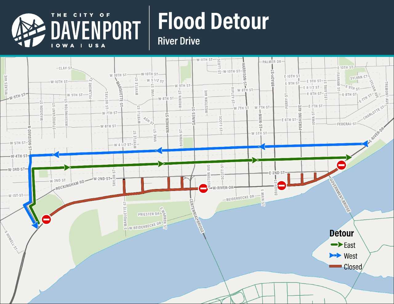
Detours - There will be two River Drive detours phases:
.
The first closures will begin Wednesday, June 26 between Division and Western Sts. on the west, and Brady and 3rd Sts. on the east.
.
When river stage 17.5 is reached on about Sunday, River Drive will be closes from Bridge to Oneida.
NOTE: The flood mitigation projects at Marquette and River Dr are not yet complete and so will not assist in alleviating this year’s flood. Expect closures to begin before water is covering the roadway to allow crews to maneuver equipment.
.
Credit Island is closed as of today.
.
Modern Woodman Park/Bix at 6/Red, White and BOOM - The steel barricades at MWP have been put in place, and games will continue until safe access can no longer be provided. Starting location for Bix at 6 is being moved to 5th and Pershing UFN.
.
Red, White and BOOM! has been postponed due to access and the fact that the barge platforms cannot be operated safely when the river is running this swiftly. The new date will be determined in conjunction with Rock Island.
.
General Info
.
Gates and pumps in low lying areas have already been closed and will continue with river rise. Crews are staging materials in preparation for the various stages. No parking signs are being posted, especially in the downtown area, as preparation begins. It is very important that we all pay attention. As the river rises walking trails and park areas will become more inaccessible, starting from the west and moving to the east. Please DO NOT DRIVE, RIDE OR WALK in flooded areas.
.
A map showing detours and road closures is attached.